Points to keep in mind
GIS is NOT an umbrella for other geospatial fields
Many people express GIS as an umbrella of which their spatial fields such as remote sensing, surface draping rendering (flight simulators) or cartography fall under. These areas are better expressed as separate complimentary entities that exist under the domain of Geomatics or geospatial technologies. This may be a convenient term but for the most part each area of study (except GIS) have risen from its own personal history. GIS has taken advantage of the evolution of these fields as well as combining it with descriptive data about geographical locations. In short we do not look to who invented GIS but rather how the concept of GIS was applied historically.
More than just technology
Much the same as how we starting this course, we realise there is a “classical” view of GIS. We also are learning that GIS (and other fields) are really being combined with Information Management strategies to be more than just technical applications.
- GIS can be used to create maps, but cartography has been used as a mechanism of communication for man essentially from cave man days.
- GIS was named when the method of linking geographic features to descriptive data by digital (computer) techniques – but these methods have been used before in analog fashion.
- There are many perceptions of the history of GIS – you have to decide what is the more accurate.
- Canada played (as still does) a large role in the formation of GIS – the contemporary digital form
GIS – Three terms in the acronym
We have discussed the term system at length so far in this course. It could be said that from cartographic output the term system is applicable as well. In fact the method of overlaying layers of information to produce results (a map) has always been used in paper cartographic output. Different plates that contain coloured layers are still used to make maps. The key to evaluating historical GIS is in the application of Information.
Examples of Historical GIS
John Snow (not the guy from Game of Thrones)
We are all familiar with Dr. John Snow’s contributions to epidemiology and GIS practices.
http://www.ph.ucla.edu/epi/snow/1859map/snowindex.html
These two web links to the UCLA John Snow site illustrate the connection of descriptive information (attributes) to spatial locations.
Studies such as this illustrate historical GIS although Cholera is not the only motivation or historical use of GIS. It does illustrate the method of storing data in GIS methods, then performing analysis with this data
The following examples come from the book Past Time, Past Place GIS for History, Edited by Anne Knowles. These examples represent inventory – building databases – of spatial and related tabular data.
Image 1: Philly 1937
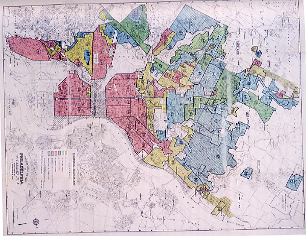
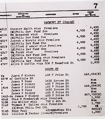
The above images illustrate mapping attributes for real estate appraisals in Philadelphia in 1937.
Image 2: Victorian GIS
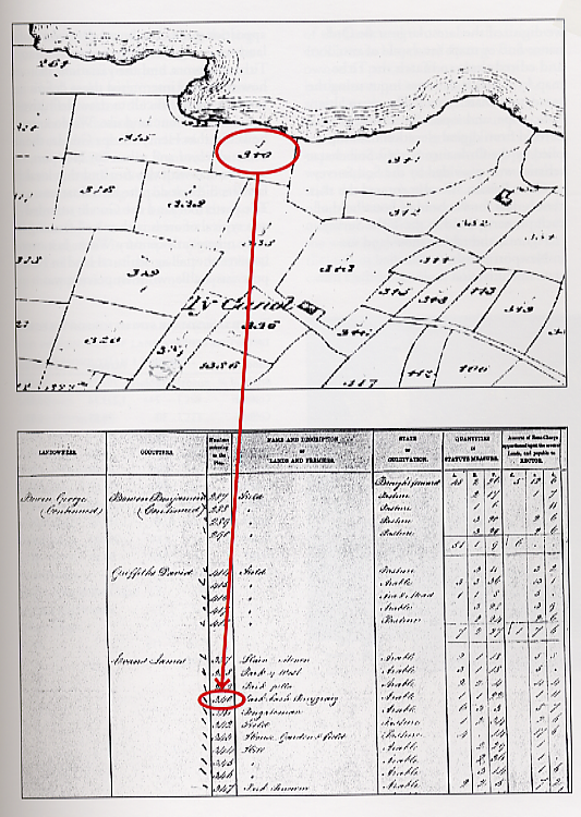
The above image details land allotment in Victorian England
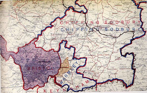
Image 3: Ordinance Survey 1909
Contemporary (Modern) GIS
Contemporary GIS (digital GIS) evolved out of the development of the computer making it possible to store spatial and informational data digitally. The first digital, or modern, what we conceive of GIS as it is today was implemented in Canada in the mid 60s. This was known as the Canadian Geographic Information System (the acronym was implemented here as well – CGIS) by Roger Tomlinson in the Canadian GIS development program with the Canada Land Inventory.
Through the seventies GIS was used mostly by government and industry for areas such as land inventory and census applications.
History of Digital GIS
Time line of GIS evolution
1960s – Mostly as research projects in the hands of Government of Universities
Some key digital mapping software developed in the 1960:
– led to the formation of GIS software and techniques that are still used today
– Some of the components and data crated were still referenced in the 1980s
– SYMAP – Harvard University
– CGIS – Canadian Land Inventory
– GRID – Harvard University
1970s
– Creation of GIS software companies made it financially possible for government and corporate institutions to make use spatial techniques
– Data sets are created for these institutions – initially census data driven
– ESRI Environmental Systems Research Institute was started (ESRI – History)
– Intergraph (1969)
– TIN project at SFU:
– evolution of software was closely tied to University development (hiring research personal)
1980s Decade for GIS (as Roger Wheate states)
– integrated software for varying demands (i.e. ESRI integrates GRID, TIN, and vector models)
– software moved to desktops (UNIX)
– starting to be taught at universities in conjunction with cartography
– Initial developments of other GIS companies and software developers to name a few:
GRASS (oldest Open Source GIS project) – https://grass.osgeo.org
IDRISI – www.clarklabs.org
Mapinfo – www.mapinfo.com
SPANS – gone baby gone (bought by PIC Geomatics and put to rest)
1990s Migration to global connectivity
– software becoming more aligned with GUI age
– still more developers and enhancements took place
– Software manufactures and users make use of the web to share data (at the end of the decade)
– standards for GIS data and exchange formats were starting to be developed
– movement to place GIS onto PC desktops (UNIX workstations and Windows OS)
– formation of the Open GIS Consortium and other GIS groups
– www.opengis.org – now called openspatial.org (standards for GIS and other geospatial domains)
– growth of map servers for connecting data sets internationally
– MapServer – The need for web maps initiates a whole new realm of accessing GIS data – – increase in training and applications
– better visualization strategies for data presentation – i.e. ArcView – Wikipedia
2000 onward
First few years of the new millennium had a focus on standards, software development and licensing.
2000 – 2010
Software development – ESRI launched ArcGIS Desktop application following ArcINFO and ArcView 3 (now moving to “Platform*)
Most other software vendors started to drop off
Open Source spatial software starts a development growth – mostly for data management (database – PostGIS- Canadian – Prince George connection) and web mapping (Mapserver – University of Minnesota)
First Conference in Ottawa 2004 (OSGIS), then onto FOSS4G
Internet Focus emerging (i.e. Mapserver for sharing data)
– ESRI continues incommunity building with thegeography network – Replaced by ArcGIS Online
– Web mapping and data storage are linking many communities together through spatial means
– Open Source GeoSpatial Foundation
– Google Earth – Taking what GIS can offer to a new audiences
– University, corporate, government and community based GIS are combining\sharing resources and techniques – GeoConnections,
– Increase integration of computer science, social science and GIS – Center for Spatially Integrated Social Science– example: look for crimestat gis in google
– Development of mini systems such as mobile units for collecting information or connecting to map servers (hand held units with GPS systems and map downloading/reading capabilities). – CyberTracker Geopaparazzi/Smash
– Small communities engaging others to connect them to the world – in their own worldview, GeoSpatial thinking can make it possible to communicate through geography.
2010-
Standards for data, data sharing and best practices are established and utilized for software and web application development
Movement for ecosystems of software and web services
– ESRI moving towards web services as well as desktop applications – ArcPro evolution of ArcGIS following theses standards
– Open Source has significant effect on setting and promoting these standards. Large growth in Open Source Software promoting interlocking applications (already has a ecosystem inherent in Open Source Model) – Open Source GeoSpatial Stack – Laurent Jegou’s diagram
– Open GeoSpatial Data – so much available now, but it was a huge battle to get data (The rebel alliance vs the huge data stores of the Empire)
– Plenty of groups gathering and offering up free geospatial data
Open Street map, ESRI, NASA/USGS, NRCAN/GeoGratis Terrapop
Some level of GeoSpatial technology is being used by virtually everyone – SnapMap!!
Great page by Caitlin Dempsey
Caitlin Dempsey has put together a nice page (and timeline link) about the history of GIS in GIS Lounge
GIS as an Integrator
Considering GIS as solely a technical tool has become a historical concept. GIS (or whatever you may want to call it) can be be utilized to bring many types of data together for numerous purposes other than making ugly maps. Many researchers will now include a spatial component into their projects (many of the courses you will be taking here at UNBC) as a way to store and connect their data to other groups. Because of the development of new perceptions of how Spatial Thinking and Technologies can be developed and applied, many are renaming\reshaping the field to label this area in their own ways.
How does this contemporary (or not so contemporary) way of spatially thinking apply to fields other than land management – i.e in the social sciences? Much of the recent GeoSpatial developments are directed to social and not soft sciences (i.e. more in how humans interact than monitoring and visualizing resources on the landscape).
Next Tutorial – Taking a look at the beginning of GIS (CGIS)
We will be looking at the videos that describe the start of the Canadian Geographical Information System on youtube. If you feel like a look back in history before next week, check out: