Topics for today
Lecture on Accuracy and Precision of GIS data
A quick look at Assignment 6 (Due November 16)
Last assignment instead of a Lab Quiz
Accuracy and Precision
Accuracy and precision lecture pdf link
Assignment 6 review
We are going to make this assignment out of 10 (lowering the value of the project or the final exam or substituting a smaller assignment instead of a lab quiz) and assignment 6 will be due Monday November 16.
Description of Assignment
We want to see the difference between using a couple tools for determining how difficult a trail may be to walk compared to checking points along a line sampled against a slope layer. You will carry out this check using the following steps:
- Use the drape tool to get elevation values “Z” values from a DEM to create a 3D line layer. Use your trail layer to initiate the process
- Use the Climb Along Line tool to generate some climbing attribute for this layer
- Create a new line layer by using the densify by interval tool with a 20 metre spacing using your trail layer as input.
- Create a new point layer by extracting these new vertices created from the densified line using the extract vertices tool
- Create a slope layer from the DEM
- Sample the new point layer against the slope layer
- Style the climb layer and the sampled point layer as graduated using the same colour scheme with the same number of classes
For your write up, describe the steps you took to get your results, and create screenshots of your two resultant layers against the slope layer as a base layer.
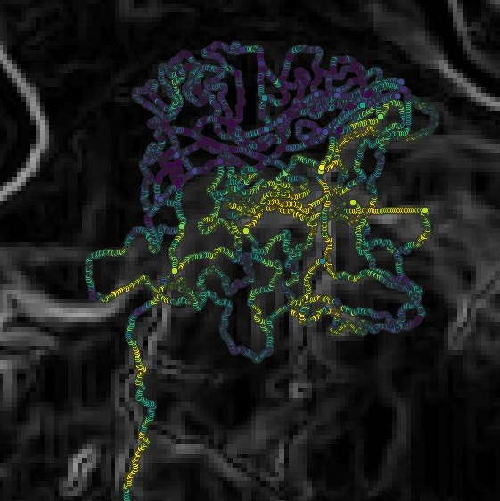
Below is an example of this type of output:
Last Assignment – no Lab Quiz
We will be going through the steps and outline of the last assignment in tutorial next week (due the following week – Week of November 23rd – in tutorial). This will involve using GPS data students collect with their mobile phones and performing some analysis with this GPS data in conjunction with free online data.